You plan to move to the Philippines? Wollen Sie auf den Philippinen leben?

There are REALLY TONS of websites telling us how, why, maybe why not and when you'll be able to move to the Philippines. I only love to tell and explain some things "between the lines". Enjoy reading, be informed, have fun and be entertained too!

Ja, es gibt tonnenweise Webseiten, die Ihnen sagen wie, warum, vielleicht warum nicht und wann Sie am besten auf die Philippinen auswandern könnten. Ich möchte Ihnen in Zukunft "zwischen den Zeilen" einige zusätzlichen Dinge berichten und erzählen. Viel Spass beim Lesen und Gute Unterhaltung!


Visitors of germanexpatinthephilippines/Besucher dieser Webseite.Ich liebe meine Flaggensammlung!

free counters

Google

Showing posts with label PAGASA. Show all posts

Tuesday, March 28, 2023

Hotter days ahead – Pagasa


A scientist at the Philippine Atmospheric Geophysical Astronomical Services Administration (Pagasa) in Quezon City checks and logs the current temperature and relative humidity in Metro Manila on Friday, March 24, 2023. The heat index in the metropolis was recorded at 39°C due to the high pressure area (HPA) and easterlies that resulted in the high temperature.

PHOTO BY J. GERARD SEGUIA


By Arlie O. Calalo


THE Philippine Atmospheric, Geophysical and Astronomical Services Administration (Pagasa) on Tuesday urged the public to take all precautions as temperatures continue to climb.

Weather specialist Samuel Duran said the growing heat could lead to health problems.

"As much as possible, limit going outdoors but if it cannot be avoided, make sure to not stay long under the sun especially at noontime and early afternoon when the heat is most intense," he said.

"Stay hydrated and wear light colored clothes to help minimize the effect of the heat index and avoid heat exhaustion and heat cramps," Duran added.

The weather agency projected the following temperatures in these areas: Metro Manila, 24 to 34 degrees Celsius; Tagaytay City, 22 to 32 degrees Celsius; Baguio City, 16 to 26 degrees Celsius; Laoag City, 24 to 32 degrees Celsius; Legazpi City, 24 to 32 degrees Celsius; Tuguegarao City, 24 to 35 degrees Celsius; Puerto Princesa City, 26 to 33 degrees Celsius in Luzon.

In Visayas: Cebu, 26 to 32 degrees Celsius; Tacloban, 24 to 31 degrees Celsius; and Iloilo, 27 to 32 degrees Celsius. In Mindanao, Zamboanga City is expected to have 25 to 35 degrees Celsius; Cagayan de Oro, 25 to 31 degrees Celsius and Davao City, 25 to 33 degrees Celsius.

Wednesday, March 15, 2023

La Niña ends – Pagasa

By Arlie O. Calalo


THE Philippine Atmospheric, Geophysical and Astronomical Services Administration (Pagasa) has declared that the cold weather called La Niña, which has led to a number of tropical cyclones in the country, has ended after over a year.

However, this does not mean that El Niño or warm weather has begun.

"Most of the climate models predict that ENSO- neutral (neither La Niña nor El Niño) is favored from March through June this year with an increased likelihood of a transition to El Niño thereafter," according to Pagasa Administrator Vicente Malano.

Although La Niña has ended, Malano said its lingering effect may still result in above-normal rainfall conditions in the coming months, which may lead to heavy rainfall, floods, flash floods, and rain-induced landslides in some highly vulnerable areas.

On one hand, El Niño increases the likelihood of below-normal rainfall conditions, which could result in dry spells and droughts in some areas of the country, he said.


In its advisory, Pagasa said the country will experience a gradual shift of wind systems as the northeast monsoon locally known as "amihan" is predicted to wane and the easterlies will become predominant this March.

Other weather systems still likely to affect the country are the ridge of high pressure areas (HPAs), low pressure areas (LPAs) and convergence zones, it said.

The state-run weather agency has predicted that at least one tropical cyclone will likely occur within this month.

Generally, most parts of the country may experience near to above-normal rainfall conditions except for some provinces over the western section of Northern Luzon and the northern part of Palawan that may receive below-normal to way below-normal rainfall within March, Pagasa said.

Saturday, February 18, 2023

LPA seen to cross eastern part of PH landmass, trigger more rains in next 3 days — PAGASA

Published February 18, 2023, 10:03 AM

by Charie Mae F. Abarca

The low pressure area (LPA) spotted near Mindanao remains less likely to develop into a tropical cyclone, but the state weather bureau’s latest forecast scenario showed that the weather disturbance will cross the eastern section of the Philippine landmass and trigger more rains in the next three days.

PAGASA’s Tropical Cyclone Threat Potential forecast showing the LPA’s low likelihood of cylone development. (Screengrab / PAGASA YouTube)

Last seen 285 kilometers east southeast of Davao City, the LPA continues to dump rains over Visayas, Caraga, Davao Region, northern Mindanao, Bicol Region, Romblon, Marinduque, and Quezon. 

“[On Saturday, Feb. 18], the LPA will be closest to Caraga Region and eastern Visayas. By [Sunday, Feb. 19] it is expected to be in the Bicol Region, while on [Monday, Feb. 20] it will be in the eastern section of northern or central Luzon, and by that time another surge of the northeast monsoon will begin,” said Philippine Atmospheric, Geophysical and Astronomical Services Administration (PAGASA) Weather Specialist Benison Estareja in Filipino on Saturday, Feb. 18.

By Tuesday, Feb. 21 PAGASA expects the weather disturbance to dissipate while crossing the northern Luzon area.

Along with the LPA, the northeast monsoon, also called “amihan,” will bring light rains and cold winds in Metro Manila and the rest of Luzon. The lowest air temperature recorded on Saturday was logged in Baguio City: 13.0°C at 4:50 a.m.

Due to the strong to gale force winds associated with the northeast monsoon, a gale warning remained hoisted in the eastern seaboards of southern Luzon and Visayas and the northern and eastern Seaboards of Mindanao; the central and western seaboards of Visayas; the western and southern seaboards of southern Luzon; as well as the seaboards of northern Luzon and the eastern seaboard of central Luzon.

ADVERTISEMENT

Fishermen with small sea vessels were advised not to venture out into the sea due to rough sea conditions.

Saturday, February 4, 2023

Has warm, dry season already started? Here’s what PAGASA has to say

by Ellalyn De Vera-Ruiz, MB

Baguio City (COMMONS WIKIPEDIA/ MANILA BULLETIN/ FILE PHOTO)

The cold air from the northeast monsoon or “amihan” continues to be experienced in large parts of Luzon and Visayas although it is relatively weak compared to the previous weeks, said a weather specialist of the Philippine Atmospheric, Geophysical and Astronomical Services Administration (PAGASA).

“Sa mga nagtatanong kung simula na ito ng tag-init o warm dry season sa ating bansa, ang sagot po natin ay hindi pa (To those who are asking if this is the beginning of summer or warm, dry season in our country, our answer is not yet),” PAGASA weather specialist Benison Estareja said on Friday, Feb. 3. 

“Makakaranas pa rin tayo ng mga pagbugso ng amihan hanggang matapos ang Pebrero dito sa malaking bahagi ng Luzon, as well as Eastern Visayas habang sa unang bahagi ng Marso ay meron pa rin tayong amihan lalo na sa may Northern and Central Luzon (We will still experience surges of northeast monsoon until the end of February in large parts of Luzon, as well as in Eastern Visayas, while in early March, we still have surges of northeast monsoon, especially in Northern and Central Luzon),” he added.

Estareja said the northeast monsoon will continue to temporarily weaken in the coming days, before another surge of amihan by mid-February.

PAGASA defines amihan as cold winds from the northeast that bring rains over the eastern side of the country.

It also records the coldest day of the year during the northeast monsoon season.

ADVERTISEMENT

The cool and dry season is from December to February, while the hot and dry season is from March to May.

In the next 24 hours, PAGASA said partly cloudy to cloudy weather with light rains due to the northeast monsoon or amihan may affect Luzon and Visayas.

Meanwhile, Mindanao will have partly cloudy to cloudy weather with isolated rain showers or thunderstorms.

PAGASA advised the public to stay vigilant against possible flash floods or landslides during severe thunderstorms.

According to Estareja, no new tropical cyclone will be seen entering the Philippine area of responsibility in the next few days, based on the latest weather forecast.

However, he said PAGASA monitored a cloud cluster over the Pacific Ocean. 

Estarejsa said Southern Mindanao may experience scattered rain showers and thunderstorms by Sunday, Feb. 5, due to the intertropical convergence zone.

Tuesday, January 17, 2023

2 low pressure areas inside PAR – Pagasa


By Arlie O. Calalo, Manila Times


TWO low pressure areas (LPAs) have been spotted inside the Philippine Area of Responsibility (PAR) although the first one may dissipate in 24 hours as both are unlikely to develop into a tropical depression, the state-run weather agency said on Tuesday.


Weather forecaster Obet Badrina of the Philippine Atmospheric, Geophysical and Astronomical Services Administration (Pagasa) told The Manila Times that first LPA was estimated some 290 kilometers east of Maasin City, Southern Leyte while the other was at 125kms west-northwest of Puerto Princesa City, Palawan.


"The LPA off Southern Leyte, which has been inside PAR for over a week, may eventually dissipate," said Badrina as he added that the other weather disturbance will also likely follow.


The Pagasa weatherman reiterated that the two LPAs would not have a chance to escalate into tropical cyclones.


However, the LPA and the shear line are bringing cloudy skies with scattered rain showers and thunderstorms over Bicol Region and Quezon, according to the 11 a.m. advisory of the weather bureau.

Friday, December 9, 2022

LPA to enter PH, may escalate into tropical depression – Pagasa


By Arlie O. Calalo, Manila Times


THE state-run weather agency said on Thursday that a low pressure area (LPA) still outside the Philippine Area of Responsibility (PAR) may develop into a tropical depression once it enters the country and would be named "Rosal".

Weather specialist Benison Estareja of the Philippine Atmospheric, Geophysical and Astronomical Services Administration (Pagasa) told The Manila Times that the LPA was last spotted some 1, 265 kilometers east of Mindanao (outside PAR).

He said its trough or extension is affecting the eastern sections of Visayas and Mindanao where cloudy skies with scattered rain showers and thunderstorms may prevail over the next 24 hours.

Meanwhile, the shear line or the point where the warm and cold air converge is bringing rains over Northern Luzon particularly in Cagayan, Apayao and Ilocos Norte, Pagasa said.

Quoting Pagasa's latest forecast, Estareja said the LPA will likely enter within the day (Thursday) and will move towards Eastern Visayas and Bicol Region.

"It has a moderate chance to become a tropical cyclone," said Estareja although he declined to say if this would further escalate into a tropical storm in the coming days.

In case the LPA will develop into a storm, it will have a domestic name of "Rosal", the 18th cyclone this year and the first this month, the Pagasa forecaster said.

Over Metro Manila and the rest of the country, the weather bureau said generally fair weather is likely over the next 24 hours although partly cloudy to cloudy skies with isolated rain showers or thunderstorms may be experienced in late afternoon and night time due to the localized thunderstorms.

Tuesday, November 1, 2022

PAGASA: Several areas in Mindanao to experience moderate to heavy rains due to ‘Queenie’

Published November 1, 2022, 9:08 AM

by Analou de Vera

Tropical Storm Queenie (DOST-PAGASA)

Tropical Storm Queenie will bring moderate to heavy rains in some parts of Mindanao on Tuesday, Nov. 1, said the Philippine Atmospheric, Geophysical and Astronomical Services Administration (PAGASA).

Queenie was last spotted 490 kilometers east of Davao City, packing maximum sustained winds of 65 kph near the center with gustiness of up to 80 km/h, the PAGASA said in its latest weather update. 

“Tonight through tomorrow: Moderate to heavy rains possible over Surigao del Norte, Surigao del Sur, and Dinagat Islands,” the weather bureau reported.

“Light to moderate with at times heavy rains possible over Eastern Visayas, Davao Oriental, and the rest of Caraga Region,” it added.

PAGASA said that flooding and rain-induced landslides are possible, “especially in areas that are highly or very highly susceptible to these hazard as identified in hazard maps and in localities with significant antecedent rainfall.”

“The hoisting of Tropical Cyclone Wind Signals is not ruled out over the eastern portion of Caraga and in some areas in Eastern Visayas today (Tuesday). Per latest track and intensity forecast, the highest wind signal that will likely be hoisted is Wind Signal No. 1,” it said. 

Queenie is “forecast to track generally west northwestward to northwestward” on Tuesday “before turning north northwestward” on Wednesday, Nov. 2, “while over the sea east of Caraga-Davao Region area,” PAGASA said.

The weather bureau said that Queenie “may weaken into a tropical depression” on Tuesday, Nov. 1, “due to increasingly unfavorable conditions. Further weakening into a low pressure area is likely by Thursday, possibly earlier.”

Wednesday, October 26, 2022

LPA off Eastern Visayas may become tropical depression in 24 hours – Pagasa


By Arlie O. Calalo October 26, 2022 


THE low pressure area (LPA) off Eastern Visayas has a big chance of developing into a tropical depression within 24 hours and it will be named "Paeng", the Philippine Atmospheric, Geophysical and Astronomical Services Administration (Pagasa) said on Wednesday.


The LPA was last spotted at about 3 a.m. some 1,010kilometers east of Eastern Visayas, according to weather forecaster John Rey Bagalanon.


Bagalanon told The Manila Times that the shear line, the point where the cold and warm air converges, is affecting Southern Luzon.


The state-run weather agency said the trough or the extension of the LPA is bringing rain and thunderstorms over Palawan, Visayas and Mindanao.


Meanwhile, the northeast monsoon or "amihan" is bringing cloudy skies with rains over Cagayan Valley, Cordillera Administrative Region, Aurora, Ilocos Region and the rest of Central Luzon, Pagasa said

Friday, October 21, 2022

Amihan season begins – PAGASA

by Charie Mae F. Abarca, MB


Brace for colder weather in the coming days because the Amihan season has officially begun!

The Philippine Atmospheric, Geophysical, and Astronomical Services Administration (PAGASA) on Thursday, Oct. 20, declared the onset of the northeast monsoon, locally called “amihan,” season in the country. 

(JANSEN ROMERO / MANILA BULLETIN)

The northeast monsoon pertains to the cold winds from the northeast that bring rains over the eastern side of the country. Following the onset of this weather system, surges of cold temperatures may be experienced across the country in the coming months.

“The northeast wind flow is expected to gradually become more dominant over Northern Luzon, bringing cold and dry air,” said PAGASA in a press statement.

La Niña

Apart from cooler winds, the northeast monsoon, according to the state weather bureau, may further enhance the ongoing La Niña. 

La Niña, or the cooling of sea temperatures in the equatorial Pacific, increases the likelihood of having “above normal rainfall conditions” that could lead to other hazards such as flash floods and rain-induced landslides, especially in vulnerable areas.

“All concerned government agencies and the public are advised to take precautionary measures to mitigate the potential impacts of these events,” PAGASA added.

In 2021, PAGASA declared the onset of the amihan season on Oct. 25.

Friday, October 14, 2022

Further intensification of ‘Neneng’ not ruled out – PAGASA

by Charie Mae F. Abarca

Tropical depression Neneng, the country’s 14th tropical cyclone in 2022, is expected to further intensify while moving over the Philippine sea, the state weather bureau said.

The Philippine Atmospheric, Geophysical, and Astronomical Services Administration (PAGASA), on Friday, Oct. 14, said Neneng is forecast to move west southwestwards in the next 24 hours before turning westward on Saturday, Oct. 15.

PAGASA’s latest forecast track showed that the weather disturbance will likely make landfall or pass “very closely” in Babuyan Islands or Batanes.

Satellite image of Neneng (PAGASA)

Last spotted 1,015 kilometers (km) east of extreme northern Luzon, Neneng was packing maximum winds of 55 kilometers per hour (kph) and gustiness of up to 70 kilometers per hour (kph). It is moving west northwestward at 10 kph.

Raising of wind signals

With Neneng’s expected close approach to the Philippine landmass, the state weather bureau warned of heavy rains that may begin to drench northern Luzon beginning Saturday, Oct. 15.

“Tropical Cyclone Wind Signal No. 1 may be hoisted [on Friday morning or afternoon, Oct. 14] over the eastern portion of northern Luzon in the anticipation of winds associated with the approaching tropical cyclone,” said PAGASA.

“Per latest intensity forecast, the most likely highest wind signal that will be hoisted is wind Signal no. 2,” it added.

The weather disturbance, according to the state weather bureau, may further intensify while traversing the Philippine sea, adding that it may reach tropical storm category by Saturday. Further intensification prior to its expected “close approach” to extreme northern Luzon is not ruled out.

Tuesday, October 11, 2022

‘Maymay’ may make landfall over Aurora or northern Quezon — PAGASA

Published October 11, 2022, 1:12 PM

by Ellalyn De Vera-Ruiz

(PAGASA / FACEBOOK)

Tropical depression Maymay maintained its strength as it slowly moved west-southwest over the Philippine Sea east of Aurora province on Tuesday morning, Oct. 11, according to the Philippine Atmospheric, Geophysical and Astronomical Services Administration (PAGASA).

In the 11 a.m. bulletin, PAGASA said that Maymay was last spotted at a distance of 285 kilometers east of Casiguran, Aurora and maintained a maximum sustained winds of 45 kilometers per hour (kph) near the center and gusts of up to 55 kph.

Should the tropical depression maintain its speed and track, Maymay may make landfall over Aurora or northern Quezon on Wednesday afternoon or evening, Oct. 12, PAGASA said.

Tropical Cyclone Wind Signal No. 1 remains hoisted over Isabela, Quirino, Nueva Vizcaya, Aurora, Nueva Ecija, and the extreme northern portion of Quezon (General Nakar, Infanta) including Pollilo Islands.

“Winds of 39 to 61 kilometers per hour (kph) may be expected in at least 36 hours or intermittent rains may be expected within 36 hours,” PAGASA said.

“Today (Oct. 11) through tomorrow morning (Oct, 12), moderate to heavy with at times intense rains [are expected] over Cagayan, Isabela, Batanes, and Apayao. Light to moderate with at times heavy rains [are also expected] over Aurora, Abra, Kalinga, Mountain Province, and Ilocos Norte,” it added.

PAGASA warned against the possibility of scattered to widespread flooding, including flash floods, and rain-induced landslides, especially in areas that are highly or very highly susceptible to these hazards.

After making landfall, Maymay may traverse the landmass of Central Luzon before emerging over the West Philippine Sea by Thursday morning, Oct. 13.

“Maymay is forecast to maintain its strength prior to its landfall. Due to frictional effects, this tropical cyclone may be downgraded to low pressure area once it emerges over the West Philippine Sea. Weakening to low pressure area while traversing over Central Luzon is not ruled out,” it added.

Thursday, September 22, 2022

LPA east of Central Luzon now tropical depression Karding


Tropical Depression Karding (Photo courtesy of PAGASA)


by Charie Mae F. Abarca, Manila Bulletin


The low pressure area (LPA) east of Central Luzon has developed into tropical depression Karding, the 11th tropical cyclone to enter and form in the Philippine area of responsibility (PAR) in 2022.


The Philippine Atmospheric, Geophysical, and Astronomical Services Administration (PAGASA) said the weather disturbance developed at 8 a.m. on Thursday, Sept. 22. Bulletins for this tropical cyclone will be issued beginning Thursday at 11 a.m.


Meanwhile, apart from Karding, the southwest monsoon, locally called “habagat,” is also being monitored. This weather system, according to PAGASA, may bring partly cloudy skies with isolated rain showers in various parts of the country. In a public weather forecast, PAGASA weather specialist Benison Estareja said that the southwest monsoon will particularly affect the western sections of Central and Southern Luzon in the next 24 hours.

Tuesday, September 13, 2022

Typhoon Inday exits PH area of responsibility; another tropical cyclone may enter PAR by Sept. 15 or 16


(PAGASA FACEBOOK PAGE)


by Ellalyn De Vera-Ruiz, Manila Bulletin


Typhoon Inday (international name: Muifa) left the Philippine area of responsibility (PAR) early Tuesday morning, Sept. 13, the State weather bureau said, as it monitors another tropical cyclone that may enter the PAR by Thursday or Friday, Sept. 15 or 16.

The Philippine Atmospheric, Geophysical and Astronomical Services Administration (PAGASA) said Inday left the PAR at around 12:40 a.m., and was already 560 kilometers (km) north-northeast of Itbayat, Batanes as of 4 a.m.

It had maximum sustained winds of 140 kilometers per hour (kph) near the center and gustiness of up to 170 kph.

While the typhoon has already left the PAR, PAGASA said the extreme Northern Luzon may still experience wind gusts.

In the next 24 hours, the entire archipelago will have partly cloudy to cloudy skies with chances of rain showers or localized thunderstorms.

Meanwhile, PAGASA continues to monitor another tropical depression outside the PAR as of Tuesday morning.

In its 5 a.m. bulletin, PAGASA said the tropical depression was estimated at 1,720 km east of extreme Northern Luzon.

It has maximum sustained winds of 45 kph near the center and gustiness of up to 55 kph, while moving eastward “slowly.”

“Modest intensification is likely today (Sept. 13) through tomorrow (Sept. 14). By Thursday (Sept. 15), improving environmental conditions will enable the tropical cyclone to intensify at a relatively faster rate. Current forecast scenario shows that this tropical cyclone will enter the PAR as a typhoon,” PAGASA said.

PAGASA weather specialist Aldczar Aurelio said the cyclone may enter the PAR by Thursday or Friday, and once inside the PAR, the domestic name “Josie” will be assigned to this tropical cyclone.

Aurelio said that based on the latest track forecast, the tropical depression may only pass through the right corner of the PAR.

“This tropical cyclone is forecast to remain far from the Philippine landmass and not directly affect the weather condition in the country,” PAGASA said.

“However, it may enhance the southwest monsoon within the forecast period. This may bring monsoon rains over the western sections of Southern Luzon and Visayas beginning tomorrow (Sept. 14) or on Thursday (Sept. 15),” it added.

Thursday, May 19, 2022

PAGASA declares onset of rainy season in PH


(JANSEN ROMERO / MANILA BULLETIN FILE PHOTO)


by Ellalyn De Vera-Ruiz, Manila Bulletin


The Philippine Atmospheric, Geophysical and Astronomical Services Administration (PAGASA) declared the start of the rainy season on Wednesday, May 18, citing the widespread rains during the last five days.


“The presence of frontal system and the occurrence of severe thunderstorms have brought widespread rains during the last five days in areas under Type I climate and other parts of the country,” PAGASA said in a statement.


PAGASA defines areas under Type I climate classification as those with two pronounced seasons—dry from November to April and wet during the rest of the year. These include Metro Manila and the western sections of Luzon and Visayas.


“Moreover, southwesterly surface wind flow was also observed during the past few days. This satisfies the criteria of the start of the rainy season over the western sections of Luzon and Visayas,” it said.


PAGASA noted that intermittent rains, associated with the southwest monsoon, locally called “habagat,” will affect Metro Manila and the western sections of the country.


However, it pointed out that breaks in rainfall events, also known as monsoon breaks, which can last for several days or weeks, may still occur.


Meanwhile, PAGASA said the ongoing La Niña may still affect some parts of the country, which may increase the likelihood of above-normal rainfall conditions in the coming months.


The State weather bureau added it will continue to monitor the day-to-day weather and long-term climate situation and provide updates when significant changes occur.

Friday, April 22, 2022

Sun about to enter ‘Solar Maximum’ phase; large sunspot groups seen – PAGASA


Sunspot group (Image courtesy of PAGASA)


by Charie Mae F. Abarca, Manila Bulletin


The state weather bureau on Thursday, April 21, released images of the Sun showing three large sunspot groups.


“Sunspots are areas on the Sun’s surface that are relatively cooler and appear dark[er] than its surroundings,” said PAGASA.


The patches, according to the state weather bureau, are “roughly the size” of Earth or about 20 up to 40 times larger than a typical sunspot.


Meanwhile, PAGASA likewise explained that the recent increase in solar activities is expected as the Sun is entering a new phase.


“The Sun is entering the Solar Maximum phase of its current solar cycle where there will be an expected increase in solar activities [such as] frequent solar flares, increased number of sunspots and the like,” said PAGASA.


“Do not look at the Sun directly without a special filter to protect your eyes,” the state weather bureau warned.

Magat Dam spilling operations halted


(National Irrigation Administration / File Photo)


by Ellalyn De Vera-Ruiz, Manila Bulletin


Authorities have stopped Magat Dam’s spilling operations on Wednesday, April 20, the Philippine Atmospheric, Geophysical and Astronomical Services Administration (PAGASA) said in its termination of flood precaution advisory.


PAGASA said that the Magat Dam in Isabela has closed its gate at around 9 a.m. Wednesday.


In its latest monitoring, Magat Dam’s water level was at 190.01 meters, which is 3 meters below its 193.0-meter spilling level.


The dam conducted discharge operations on April 14 amid rains from the northeasterly surface wind flow.


In the past 24 hours, PAGASA recorded less than 1.0 millimeter of rainfall over the Magat watershed.


Meanwhile, it projected less than 5 millimeters of rainfall in the next 24 hours.


“With this development and unless significant rain occurs, this is the final dam situationer for this period. Flood forecasting and warning system for dam operation for Magat Dam is now terminated,” PAGASA’s advisory read.


PAGASA said the entire country can expect hot and humid weather with isolated rain showers because of the easterlies, or the warm winds from the Pacific Ocean, in the next few days.


Saturday, April 9, 2022

Possibility of LPA developing into tropical depression not ruled out — PAGASA


The LPA was seen 375 kilometers east of Surigao City, PAGASA said in an advisory issued at 11 a.m.

MANILA, Philippines — State weather bureau PAGASA said Friday it is not ruling out the possibility of a low pressure area off Mindanao becoming a tropical depression.

The LPA was seen 375 kilometers east of Surigao City, PAGASA said in an advisory issued at 11 a.m.

“The development of this LPA into a tropical depression is not ruled out. It is embedded along the Intertropical Convergence Zone affecting Visayas and Mindanao,” it said.

According to PAGASA, the weather disturbance will dump moderate to heavy rains over Catanduanes, Albay, Sorsogon, Eastern Visayas, Surigao del Norte, Agusan del Norte, northern portion of Surigao del Sur, and Dinagat Islands in the next 24 hours.

Meanwhile, light to moderate with at times heavy rains will be experienced over the southern portion of Quezon province, Romblon, Marinduque, and the rest of Bicol region, Visayas and Mindanao.

“Under these conditions, scattered flooding and rain-induced landslides are likely, especially in areas that are highly or very highly susceptible to these hazards as identified in hazard maps and in areas with significant antecedent rainfall,” PAGASA said.

Metro Manila will experience isolated rainshowers or thunderstorms due to localized thunderstorms on Friday.

Weather forecasters are also monitoring a tropical cyclone outside the Philippine area of responsibility. It was last seen over 2,000 km east of Mindanao. — Gaea Katreena Cabico

Saturday, April 2, 2022

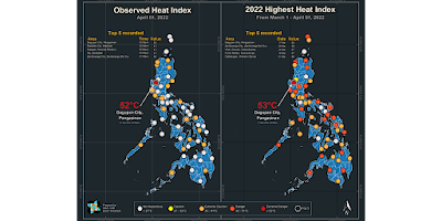
Dagupan City sizzles at 52°C heat index


by Ellalyn De Vera-Ruiz, Manila Bulletin


The highest heat index in the country on Friday, April 1, was recorded in Dagupan City, Pangasinan at 52 degrees Celsius (°C).


The Philippine Atmospheric, Geophysical and Astronomical Services Administration (PAGASA) defines heat index as the measurement of how hot it feels when relative humidity is factored in with the actual air temperature.


If the heat index is over 52°C, PAGASA said there is “extreme danger” as “heatstroke is imminent.”


Based on its monitoring on Friday, the five monitoring stations that logged the highest heat index values for the day were:


Dagupan City, Pangasinan (52°C, 2 p.m.)


Masbate City, Masbate (41°C, 2 p.m.)


Calapan, Oriental Mindoro (41°C, 2 p.m.)


Iba, Zambales (41°C, 2 p.m.)


Zamboanga City, Zamboanga del Sur (40°C, 1 p.m.)


With heat indices between 41°C and 51°C, PAGASA said there is impending “danger as heat cramps and heat exhaustion are likely,” while “heat stroke is probable with continued activity.”


So far, Dagupan City registered the highest heat index in 2022 at 53℃ on March 17.


Heat index is at least 3 degrees Celsius (°C) to 4°C higher than the actual air temperature.


However, PAGASA said that full exposure to sunshine can increase the heat index by 8 degrees Celsius.


From March to May, PAGASA provides heat index monitoring and forecast information that can be viewed on their website.

Saturday, January 29, 2022

Pagasa sees warmer days ahead


Michael Punongbayan - The Philippine Star 

January 29, 2022 | 12:00am


MANILA, Philippines — Though the Philippine Atmospheric, Geophysical and Astronomical Services Administration (PAGASA) is yet to declare the end of the northeast monsoon season, it is now predicting warmer days ahead for Metro Manila and the rest of the country.


In a three-day weather forecast yesterday, the state weather bureau said the National Capital Region can expect temperatures ranging from 23 to 33°C from Saturday to Monday.


Baguio City, the country’s summer capital, is also starting to warm up a little, with temperatures ranging from 15 to 24°C during the next three days.


PAGASA said the shear line or the meeting of the northeast monsoon and the easterlies is affecting Northern Luzon, thus bringing warmer weather despite cloudy skies and isolated rainshowers.


The easterlies or the warm air coming from the Pacific Ocean will affect Central Luzon down to Mindanao, resulting in warmer weather but with localized thunderstorms.


PAGASA said no low-pressure area is expected to enter the Philippine area of responsibility until the end of the month.


The state weather bureau declared the onset of the northeast monsoon season in late October 2021 which was expected to cold temperatures to Metro Manila and the rest of Northern Luzon until January to February this year.

Wednesday, December 1, 2021

TS 'Nyatoh' to enter PAR soon; rains over northern, central Luzon due to 'amihan' — PAGASA


by Ellalyn De Vera-Ruiz, Manila Bulletin

The Philippine Atmospheric, Geophysical and Astronomical Services Administration (PAGASA) continues to monitor a tropical storm, with an international name “Nyatoh,” as it may enter the country’s area of responsibility between Wednesday afternoon and evening, Dec. 1.

PAGASA weather specialist Aldczar Aurelio said the center of Nyatoh was located 1,330 kilometers east of southern Luzon at around 3 a.m., Wednesday.

It has maximum sustained winds of 85 kilometers per hour (kph) near the center and gustiness of up to 105 kph while moving west-northwestward at 15 kph.

Aurelio said Nyatoh will be assigned its local name “Odette” once inside the Philippine area of responsibility (PAR) Wednesday afternoon or evening.

He added that the storm is only expected to stay briefly inside the PAR and may have no direct effect on the country in the next few days.

However, Aurelio said PAGASA will continue to monitor this weather disturbance for a possible change in the scenario.

PAGASA said the northeast monsoon, locally called “amihan,” will be the dominant weather system, particularly affecting Luzon.

In the next 24 hours, cloudy skies and rains may prevail over Batanes, Cagayan, Isabela, Quirino, and Aurora.

PAGASA warned those in these areas to stay vigilant against possible flash floods or landslides, particularly in the event of moderate to, at times, heavy rains.

Metro Manila and the rest of Luzon will only have partly cloudy to cloudy skies and isolated light rains due to the amihan.

Meanwhile, Visayas and Mindanao may experience partly cloudy to cloudy skies with isolated rain showers due to localized thunderstorms.

Those in Visayas and Mindanao should also remain vigilant as severe thunderstorm activities may sometimes trigger flash floods or landslides, PAGASA said.